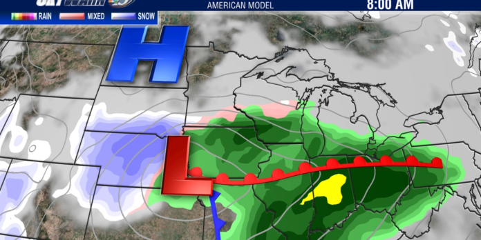
EAU CLAIRE, Wis. (WEAU) – We’re just a few days into 2023 and the first winter storm is already set to move into Western Wisconsin. Despite it being January, the lack of significant cold air is going to make for a variety of precipitation types over the next day or two as it will again be a slow moving system. Though scattered light snow is possible through early this evening, much of our area will remain dry until after 9pm tonight. The leading edge of precipitation will then expand eastward, bringing parts of the area some minor snow accumulation before a transition to freezing rain and rain occurs. The precipitation is not likely to be widespread tonight, with northern locations possibly remaining mostly dry. Temperatures in the upper 20s will slowly rise to around freezing by daybreak Tuesday. Winter weather alerts will go into effect later this evening and continue through Tuesday.
Snow, ice and rain arrive tonight and continue Tuesday (weau)
A more widespread band of precipitation is then expected to fill in and work through all of the area starting Tuesday morning and into the afternoon. This will come as mostly rain, transitioning to mixed precipitation and just snow up to the north and west where it will be slightly colder. It is during this time when much of the expected snow accumulation will occur to the north and west of Eau Claire. This band of precipitation will then lift north, tapering to just patchy drizzle for the rest of the afternoon and evening hours. Here is a look at expected snow and ice accumulations in the area.
A wintry mix of snow and freezing rain can be expected through Tuesday night (weau)
Much of the forecast uncertainty that remains is centered around these precipitation types and how quickly they may transition from snow to ice or to rain. Regardless, there will be significant impacts to travel, so use extreme caution as roads, sidewalks and driveways may be icy and in some places snow covered. Once we get deeper into Tuesday night we do expect another round of precipitation to fill back in as the storm sits nearly stationary just to our south. This again may initially be a wintry mix with a variety of precipitation types, before changing to just snow by early Wednesday. Snow showers look to now linger through much of the day before the low finally moves out, leading to the potential for another 1-4″ of accumulation. Changes to the forecast are still possible, so keep checking in for updates here at weau.com, on the Skywarn13 weather app, and on WEAU social media platforms.
Copyright 2023 WEAU. All rights reserved.
A messy wintry mix arrives tonight with travel impacts through Wednesday
LEAVE A REPLY
Recent Comments
on Army vs. Coastal Carolina live stream, how to watch online, CBS Sports Network channel finder, odds
on AL Rookie of the Year Julio Rodriguez Spreads Joy and Sportsmanship to the Youth of Loma de Cabrera
on After UFC Fallout, Conor McGregor Offers a Valuable Piece of Advice to Free Agent Francis Ngannou
on Dubai International Airport sees 41.6 million passengers in first half of year, more than in 2019
on Devout athletes find strength in their faith. But practicing it and elite sports can pose hurdles
on Despite strong Lunar New Year holiday data, consumer spending in China isn’t roaring back just yet
on Dave Portnoy: Taylor Swift’s security should ‘drag Kim Kardashian to jail’ if she attends Eras Tour
on CONCEPT ART: New Details Revealed for Disney Cruise Line Lookout Cay at Lighthouse Point Destination
on “Completely Knocked Me Out”: Rob Lowe Recalls Boxing Match With Tom Cruise On 1983 Brat Pack Classic
on CBS Sports, Serie A announce new TV rights deal; Paramount+ to air over 400 Italian soccer matches
on Cam Newton’s Violent Public Incident Draws Hilarious Reaction From 3x All-Star: “Where Do I Sign Up
on Boston College vs. Army live stream, how to watch online, CBS Sports Network channel finder, odds
on Angel Reese Launches Foundation Dedicated To Empowering Women Through Sports & Financial Literacy
on A weaker dollar, skyrocketing prices and ‘record’ visitor numbers: Good luck in Europe this summer


Thank you for always being open and honest with your readers It’s refreshing to see a blogger who is unafraid to be vulnerable and real